
Mapping Data
 06-23-2012, 07:26 PM
#1
AZ Community Team
Thread Starter

Join Date: May 2007
Location: N35�03'16.75", W 080�51'0.9"
Posts: 32,488
Received 7,771 Likes
on
4,342 Posts
Mapping Data
What's the easiest way to map a bunch of data?
I have city/state, sales $, and time spent on service.
I'd like to see if 1.) service time is in the areas where the $$ is and 2.) if service personnel are located where the need is.
I'd also like to add 3rd or 4th dimensions to scale sales (bubbles or dots of varying size) and color to split service and/or customers by type/catagory.
I don't have Map Point. I'm really hoping to find a free Excel add-on or something internet based.
 06-23-2012, 08:00 PM
#2
Sanest Florida Man
Pivot Table in Excel?
 06-23-2012, 08:49 PM
#3
AZ Community Team
Thread Starter
Join Date: May 2007
Location: N35�03'16.75", W 080�51'0.9"
Posts: 32,488
Received 7,771 Likes
on
4,342 Posts
06-23-2012, 09:52 PM
#4
Sanest Florida Man
Well besides map point I don't know. There may be some program that adds a layer over google maps
06-23-2012, 10:17 PM
#5
AZ Community Team
Thread Starter
Join Date: May 2007
Location: N35�03'16.75", W 080�51'0.9"
Posts: 32,488
Received 7,771 Likes
on
4,342 Posts
I downloaded the 60-day Map Point trial. If it works out, maybe I'll just buy a copy.
06-24-2012, 12:01 AM
#6
AZ Community Team
Thread Starter
Join Date: May 2007
Location: N35�03'16.75", W 080�51'0.9"
Posts: 32,488
Received 7,771 Likes
on
4,342 Posts
Map Point looks like it'd work, but I have to slice & dice my data a bit more to get the other dimensions. Which is fine.
Too bad it retails for ~$300 .... .
.
Too bad it retails for ~$300 ....
.
06-24-2012, 12:20 AM
#7
Sanest Florida Man
Sign up for technet standard for $200 and get it for free. Though you'd technically be violating the EULA if using it for business.....
The following users liked this post:
thelastaspec (06-24-2012)
Trending Topics
06-24-2012, 03:55 PM
#8
AZ Community Team
Thread Starter
Join Date: May 2007
Location: N35�03'16.75", W 080�51'0.9"
Posts: 32,488
Received 7,771 Likes
on
4,342 Posts
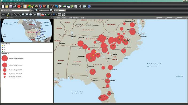
Well, I think I'm going to have to break down and buy a copy. Found some on ebay (non-academic) for ~$150 - $200.
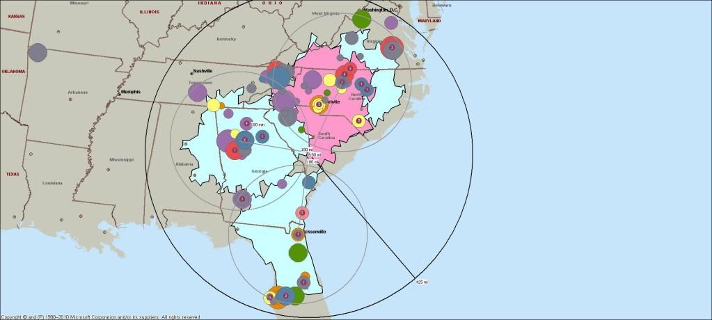
Bubble size = $
Bubble color = type
Background = drive time map
etc.
Nice tool.
Bubble size = $
Bubble color = type
Background = drive time map
etc.
Nice tool.
06-24-2012, 04:08 PM
#9
I miss my 03 CL-S :(
There are quite few free options... In the past I've done similar things with Google Charts:
https://developers.google.com/chart/...llery/geochart
Also, ManyEyes (but realize your viz will be public - you can obfuscate labels to get around privacy issues):
http://www-958.ibm.com/software/data...ounty_Map.html
A couple I've never used but have meant to look into are OpenHeatMap (http://www.openheatmap.com/) and GeoCommons (http://geocommons.com/)
The following users liked this post:
Bearcat94 (06-24-2012)

Thread
Thread Starter
Forum
Replies
Last Post
cycdaniel
1G TSX Performance Parts & Modifications
8
12-17-2019 10:58 AM
rockyboy
2G RDX (2013-2018)
46
01-25-2016 06:00 PM
bearingman07936
5G TLX Audio, Bluetooth, Electronics & Navigation
6
01-07-2016 03:22 PM
soupi
2G TSX Audio, Bluetooth, Electronics & Navigation
14
11-15-2015 11:15 AM
ExcelerateRep
4G TL Performance Parts & Modifications
8
10-14-2015 08:20 AM